Construction Economics and Building
Vol. 26, No. 2
2026
ARTICLES (PEER REVIEWED)
Using LiDAR Technology for Occupational Therapy Home Assessment: Case Study Observations
Rosemarie Rusch1,*, Judith George2, Johari Hussein Nassor Amar1, Susan Brandis2
1 Faculty of Society and Design, Bond University, Gold Coast, Australia
2 Faculty of Health Science and Medicine , Bond University, Gold Coast, Australia
Corresponding author: Rosemarie Rusch, rrusch56@bigpond.com
DOI: https://doi.org/10.5130/324y0w08
Article History: Received 14/05/2025; Revised 26/02/2026; Accepted 23/03/2026; Published 08/07/2026
Citation: Rusch, R., George, J., Amar, J. H. N., Brandis, S. 2026. Using LiDAR Technology for Occupational Therapy Home Assessment: Case Study Observations. Construction Economics and Building, 26:2, 1–19. https://doi.org/10.5130/324y0w08
Abstract
A home safety assessment by an occupational therapist is an essential and extensive analysis of the physical built environment to identify potential environmental risk factors, a problem exacerbated by severe workforce shortages. Although research has been conducted regarding the use of telehealth, using, for example, smartphones, tablets, and videoconferencing, limited literature has assessed the efficacy of scanning equipment such as light detection and ranging (LiDAR). It is important that the home environment be contextualised to inform rehabilitation, discharge planning, and potential home modification to ensure quality of care. Using a simulated case study design, this research tested the use of LiDAR images for home risk assessments by occupational therapists. Current assessment processes focus on an in-person environmental assessment and require adaptation to be valid with LiDAR images. Preliminary findings indicate the potential of using LiDAR in a health context; however, refinements to the protocol are required. Scanning to meet the needs of an occupational therapy assessment would be enhanced by clear protocols for technical scanning. The novel intersection of construction professionals and occupational therapists was positive in identifying opportunities for further research. Results of the findings indicate that using LiDAR could contribute substantially to occupational therapy home assessments. Practical significance for appropriate home modification could also benefit construction. Follow-up research is being undertaken to develop an appropriate protocol for collaboration between allied health industry and built environment professionals.
Keywords
LiDAR Technology; Home Modification; Digital Technology; Occupational Therapy; Built Environment
Introduction
Existing LiDAR technology has the potential to be transferable to a range of applications, but has yet to be applied within a clinical healthcare setting. Traditional occupational therapy home assessments are resource-intensive and limited in reach, and LiDAR offers a digital, scalable alternative. Consequently, a proof-of-concept case study was developed as an important first step to exploring this potential for residential healthcare infrastructure solutions. LiDAR is a cutting-edge technological advancement that can capitalise on this movement in client care and extend the reach of effective health support. Occupational therapy (OT) home assessments were used to illustrate where LiDAR can be applied in a clinical healthcare setting to improve home safety for older people and people living with disabilities. This paper is part of a larger study leveraging LiDAR, three-dimensional (3D) modelling, and user-friendly building information modelling (BIM)-based platforms for stakeholders (primarily healthcare providers, developers, and end-users) to tackle the inherent challenges facing Australia’s ageing and disabled populations by focusing on innovative solutions for home healthcare infrastructure.
Consent prior to data collection was obtained under Bond University HSM Ethics Number SB03285.
The key aim of this research was to explore the effectiveness and feasibility of LiDAR technology as a cost-effective alternative to traditional in-person home assessments. A secondary aim was to improve design and planning for home modifications and provide a guide for a range of research and cross-disciplinary management aspects through digitally built environments. The opportunity to use LiDAR within a healthcare context for remote care has the potential to improve timely access to health services and improve the lives of many (Cha, 2025). Parallel to increasing demand, the health workforce is stretched (Poulos et al., 2021). Investigating LiDAR technology as an alternative method for performing home assessments for older adults can add value and support innovative workforce redesign when compared to the routine practice of in-person visits and is in alignment with telehealth approaches (Read et al., 2020).
History of LiDAR
“Since its inception, just about three years ago, the laser has stimulated the imagination of scientists in practically all fields of endeavor. The unusual properties of the laser beam have opened up for research an unexplored area in the broad spectrum of electromagnetic radiations” (Goyer & Watson, 1963).
LiDAR sensors may seem like recent technology; however, as Goyer and Watson (1963) indicated, the term LiDAR was introduced in the early 1950s to describe a system in which a transmitter (light emission) and receiver (signal detection) are collocated (Filioglou, 2020). By the early 1970s, the technology was being used in space for the first time on Apollo 15 when NASA used LiDAR sensors in their explorations for mapping the surface of the Moon, Mars, and Mercury. For the rest of the decade, the primary purpose of LiDAR was topographic mapping (Abshire, 2010; Filioglou, 2020). Advances in technology since then have come a long way. Abshire (2011) stated that dramatic progress since the early 1990s has enabled new geophysical science and discoveries, yet anecdotal evidence suggests that the use of LiDAR has an expanding range of applications in the architecture, engineering, construction, and operation (AECO) industry for built environment and infrastructure real-world practice (Wu et al., 2022).
LiDAR technology applications
The ability to scan the environment and create 3D digital models to analyse, manipulate, and modify (Harrap & Lato, 2010; Pramod & Akshay, 2022; Skrzypczak et al., 2022) is based on using light in the form of laser pulses, which is reflected off different shapes, objects, and surfaces to replicate the environment (Roriz et al., 2022). Each point reflected on the surface scanned has x, y, and z coordinates in the area. The millions of points measured are combined to create a point cloud three-dimensional dataset of the scanned environment. LiDAR may be used through mobile, terrestrial, and airborne methods (Li et al., 2021) and is currently applied in industries such as agriculture, self-driving cars (Müller, 2024), geological mapping (Dassot et al., 2011; Roriz et al., 2022), planning (De Souza et al., 2015), architecture, construction (Esfahani et al., 2019; Skrzypczak et al., 2022), real estate (Matrixian, 2023), and infrastructure. The prospect of this technology is limitless, yet the United States’ National Oceanic and Atmospheric Administration (NOAA) (2012) warns, “there are many considerations and trade-offs that must be understood in order to make sound decisions about the procurement, processing, and application of [LiDAR] data”.
Practical applications of LiDAR technology within the AECO industry have the potential to be adapted to other fields. Integrated with BIM, Nguyen et al. (2020) suggested that LiDAR data improve the efficiency of the quantity management process. BIMs are increasingly used in iterative collaborative processes for design, project planning, cost optimisation, risk mitigation, and conflict minimisation. In architectural design, studies of digital heritage and reconstruction are gaining traction, with LiDAR a critical factor in documenting existing structures (Markovinović et al., 2022). Heritage building management is hampered by a lack of documentation and availability of as-built information, making informed decisions and resource allocation difficult for sustainable conservation, retrofit, or refurbishment. This can result in inefficient project management, increased costs, and increased maintenance schedules (Volk et al., 2014; Jamal et al., 2021; Khan et al., 2022). LiDAR has been shown to overcome these issues and has been effective in documenting existing structures for preservation or retrofitting. Hence, this technology shows potential to inform decisions by occupational therapists for home modifications prior to client discharge from the hospital. In recent years, as-built data have been increasingly digitalised. As Beex (2017) noted, LiDAR datasets are often freely available online, and updated data offer a unique opportunity to add to existing sets in a more accessible way for non-technical users. Nonetheless, despite powerful software applications, automatic classification of point cloud data is not 100% accurate, and manual editing is often necessary depending on the intended end-user needs. Hwang and Shim (2021), for example, found that while 3D technology showed potential, there was a need to train users to become familiar with the complex software installation, low intuitiveness, and issues of image quality and measurement validity during scan rendering. Moreover, Almukhtar et al. (2021) confirmed that digitalising large amounts of geometric information can be overwhelming and requires appropriate survey techniques not only for capturing building information but also for managing, visualising, and developing a framework that can assist professionals in their decision-making.
Wu et al. (2022) confirmed that using a single technology may not provide for the comprehensive management requirements of the AECO industry. Consequently, LiDAR provides a starting point for integration with other data capture processes, such as ground penetrating radar (GPR) and infrared (IR) thermography, as non-destructive techniques for structural evaluation. Digital twin (DT) technology, integrated with LiDAR, incorporates the physical entity, the virtual entity, and the connection of data to create a dynamic model. Immersive technologies like virtual reality/augmented reality (VR/AR) have been used to simulate hazardous construction scenarios using point cloud data for construction safety management and for documenting the existing conditions of buildings for post-occupancy evaluation and retrofit (Ghanbari et al., 2024). This has the potential to be similarly used in documenting the existing conditions of client homes for occupational therapy assessments. Nonetheless, as Almukhtar et al. (2021) noted, collecting insufficient data could render a model useless for its intended use, while collecting too much data will take a longer time and more effort and will result in redundant data, indicating a need for close collaboration between technicians and health professionals.
Recently, the real estate industry has increasingly adopted LiDAR to improve operations, with virtual tours becoming particularly valuable during the COVID-19 pandemic to enable remote property inspections. LiDAR allows precise room measurements, replacing traditional manual methods (Dollard, 2021). The process of mapping a room with LiDAR is efficient and straightforward, simplifying data collection and processing for detailed spatial representations of a wide variety of property characteristics derived from a semantically rich 3D building model (Kara et al., 2020; Moss, 2023). Moreover, smartphones are increasingly equipped with LiDAR, adding an accessible technological tool to accurately map interior spaces to augment automated valuation models (Burrows, 2023; Matrixian, 2023). Consequently, this research discusses case study observations about the use of LiDAR for occupational therapy home assessments based on existing as-built scanning processes and feedback about its efficacy from occupational therapy researchers.
Literature review: related work
Generally, home modifications involve many stakeholders: statutory authorities, medical and allied health professionals, clients, designers, and builders, among others. Occupational therapists are health professionals who enable individuals to overcome challenges and engage in their daily activities to achieve independence and overall health and well-being (Reitz and Scaffa, 2020). Home assessments are integral to an occupational therapist’s role (Read et al., 2020) to facilitate a smooth transition for the patient from hospital to their home environment and potentially reduce the risk of readmission. Home assessments involve visiting the client’s home to perform an assessment of the levels of safety and risks and to provide recommendations to create an environment better suited to the client’s needs after their medical event (Lockwood et al., 2020).
The current practice of occupational therapy home assessments is undertaken through extensive analysis of the physical environment at a client’s home to identify potential environmental risk factors using a standardised home assessment tool (Nix & Comans, 2017; Carrington & Shahidul Islam, 2023; Hughes et al., 2023; Leung & Brandis, 2023). Following an assessment, an occupational therapist makes recommendations for home modifications and/or prescribes adaptive equipment.
Considering a client’s interaction within their home environment is central to the role of occupational therapists (Lockwood et al., 2020) who seek to reduce environmental demands on clients by increasing the safety and usability of the home (Lockwood et al., 2020). It is therefore important that the context of the home environment informs rehabilitation, discharge planning, and potential home modification to ensure quality of care (Ninnis et al., 2019), particularly for clients with ongoing functional or physical limitations. However, there are several barriers to current practices in occupational therapy home assessments.
Current barriers
There are several limitations to current practice, particularly in Australia’s rural and remote areas. Such services require costly resources, funding, and time (Lannin et al., 2011), many of which are exacerbated by severe workforce shortages and geographical distance, contributing to difficulties with access for home assessments (Almog & Gilboa, 2022). For example, when assessing the use of videoconferencing for home assessment, Latulippe et al. (2022) stated that cost and time factors were barriers to home visits prior to hospital discharge in some countries, such as Canada, the UK (Money et al., 2015), and Australia (Harris et al., 2008). Moreover, miscommunication between the many stakeholders involved in home modifications can lead to misunderstandings, which can impede the process and negatively impact the outcomes for the client (Hwang & Shim, 2021). Consequently, new technologies may offer a solution to these barriers.
While the use of smartphones and virtual technology (VR) has demonstrated the capacity for identifying potential hazards and assisting occupational therapists with their recommendations, limitations such as bandwidth and internet coverage remain (Read et al., 2020; Hwang & Shim, 2021). There is limited literature that has assessed the efficacy of scanning equipment such as LiDAR for optimising the environment, although LiDAR forms the basis of a range of interactive technologies, such as 3D models, walkthroughs, and simulations that could enable occupational therapists to envision and plan the application of assistive equipment or home modification in consultation with the client.
Physical aspects of the home environment, including room layout, stairs, hobs before doorways, the height of furniture, and, particularly, rooms such as bathrooms and toilets, have been shown to be locations where older adults are more likely to fall (Tanner et al., 2008), confirming that the settings in which older people live often contain hazards that contribute to fall risk. Falls are the primary cause of injury and disability for older people, creating a significant threat to their health and independence in the home environment (Chaudhuri et al., 2014). Furthermore, Pynoos et al. (2010) described various extrinsic risk factors related to the home environment, including slippery surfaces, inadequate lighting, loose or worn carpets, unsupportive or badly arranged furniture, poorly designed bathtubs, toilets, and fixtures in the bathroom, general clutter, and pets underfoot, all of which can be communicated using LiDAR technology. Conversely, well-designed home environments and effective home modifications should match people’s capabilities, which may have declined. Home modification refers to the conversion or adaptation of the home environment that enhances the person’s physical safety by making everyday tasks easier, increasing comfort, reducing the number of accidents, and supporting independent living (Pynoos et al., 2010).
Bhandarkar et al. (2021) considered LiDAR in the context of remote patient monitoring for geriatric fall prevention, post-operative recovery monitoring, and home safety assessment. However, their research was limited to reviewing the potential for LiDAR technology by summarising literature about three use cases: (1) fall prevention, (2) monitoring post-operative recovery, and (3) home safety for infants and toddlers. Their study did not extend to primary data collection but provided an overview of potential benefits and barriers for the abovementioned cases. It is important that the effectiveness of the technology for use in home assessments is tested and evaluated firsthand. A consistent stream of data regarding the home environment can therefore be contextualised to inform rehabilitation, discharge planning, and potential home modification to drive quality of care based on robust information, which is critical to this study.
Frøvik et al. (2021) provided a proof of concept for a low-cost, non-invasive (compared to video camera monitoring, for example) LiDAR-based monitoring system to overcome one of the main challenges related to wearable sensors; the person has to remember to wear the unit. While LiDAR is considered to be an enabling technology for a non-invasive monitoring system for making users feel safer and providing a higher degree of independence in their own home environment, two significant and limiting factors are the degree of intrusion of the technology in areas such as bathrooms and privacy concerns related to the management of the acquired information (Frøvik et al., 2021).
When combined with other 3D processing software and visualisation tools, the use of LiDAR offers potential alternatives to complement and improve communication between the client and specialist stakeholders in the home modification process. However, challenges for users unfamiliar with LiDAR require further investigation.
Research method
This research is a collaborative case study initiative between the BIM and property disciplines, the Faculty of Society and Design, and the Occupational Therapy program within the Health Sciences and Medicine Faculty at Bond University, which builds on previous research. For example, Leung and Brandis (2023) demonstrated that it is feasible to conduct a home assessment for modification to reduce or prevent falls by testing and creating a protocol designed for capturing images of the home environment using smartphones. However, there were limitations to these assessments, such as inaccuracy or inability to measure furniture height, stability and the use of mobility aids in their environment, and images that were hard to decipher. While the use of smartphones has shown that it is possible for occupational therapists to perform home assessments virtually through images taken (Leung & Brandis, 2023), evidence has shown that there are alternative methods to performing routine home assessments to ensure an individual’s safety and well-being (Palmon et al., 2004; Threapleton et al., 2017; Ninnis et al., 2019; Read et al., 2020; Latulippe et al., 2022). The current project extends existing research by investigating the feasibility of using LiDAR technology as an alternative method for conducting home assessments.
Research question
The following research question was generated: Can the use of LiDAR technology for scan to BIM be an effective and cost-efficient replacement and/or support for traditional in-home assessments to inform modifications that reduce fall risks and enhance home safety for older adults and people with disabilities in Australia?
Research strategy
An explorative case study approach was adopted, as such case studies use holistic descriptions and analysis in a specific context to provide insight into real-life situations (Lauckner et al., 2012; Yin, 2018). The focus of case study research is the questions of “how” and “why”, making it appropriate for exploratory studies. Gerring (2004) defined case studies as intensive studies of a single unit that provide understanding of a larger class of similar units, while Merriam (2009) posited that a case study provides an in-depth description and analysis of a bounded system, characterised by the unit of analysis, not the topic of investigation.
A qualitative case study is valued for its ability to capture complex action, perception, and interpretation and can be particularistic, meaning that it focuses on a particular situation, event, program, or phenomenon, as in this study. This specificity of focus makes it an especially good design for questions arising from everyday practice. Case studies can bring about the discovery of new meaning, extend the reader’s experience, or confirm what is known. “Previously unknown relationships and variables can be expected to emerge from case studies leading to a rethinking of the phenomenon being studied. Insights into how things get to be the way they are can be expected to result from case studies” (Stake, 1981, p. 47). As a concurrent exploratory study, therefore, the following were considered:
• The feasibility of conducting an environmental fall risk assessment using LiDAR technology for scan to BIM, with variables that included resource requirements and quality indicators.
• Occupational therapists’ capability requirements to access and accurately assess LiDAR-based data for fall risk using a standardised home assessment tool.
• The barriers, enablers, and future opportunities of using LiDAR as a basis for rich data provision to enhance health outcomes.
Simulated case protocol
Ten hypothetical case studies for transitioning back home were selected through purposive sampling, the number based on a range of typical clinical issues requiring home assessment prior to hospital discharge. Bond University staff volunteered their homes for LiDAR scanning for these hypothetical scenarios developed by occupational therapy researchers. For the proof-of-concept stage and without negating the value of a feasibility study, real patients were not sought due to the risks of using real people in what is a novel intervention. The following assumptions and limitations were applied in relation to the simulations:
• Clients were older people (aged 65 and over, or 55 and over if Indigenous).
• Areas to be assessed were the main places where falls occur in the home—bedroom, bathroom, and toilet. Access to the dwelling was also included as a key enabler to independent living.
• A variety of typical home types were scanned—units, detached homes, villas, apartments, and highset Queenslanders.
The selected cases supported an exploratory methodology, with the intent of identifying benefits and barriers. The LiDAR technician was briefed about the patient’s needs and the assessment process prior to scanning to better support them in shadowing and taking direction from the investigating OT1 during the home assessment. Specific characteristics of LiDAR as a tool included selecting cases for home environmental measurement and collaborative decision-making concerning the technical aspects related to hypothetical scenarios.
Hypothetical scenarios targeted a control group consisting of older people and rehabilitation patients with diagnoses such as hip fracture, amputation, frailty, stroke, and neurological conditions who required discharge planning home assessments. Two occupational therapists collaborated on the clinical assessment, with OT1 undertaking the standard physical assessment and OT2 assessing the LiDAR scans remotely, with both OTs using the Westmead Home Safety Assessment Tool (WHSAT) with 24 out of 72 items of the potential hazards selected. For example, items in a bedroom could be related to the height or stability of the bed, whether there was poor access (spatial and clearance measurements), or whether there were hazards such as trailing curtains or bed covers in traffic ways. The selected items aligned to the assessment of the bedroom, bathroom, and toilet, considered to be the main fall areas in a home (Clemson et al., 2014). Moreover, they can be among the areas with the highest cost to modify, depending on the outcome of the occupational therapy assessment of client needs (NDIS, 2022).
The hypothetical clinical scenarios enabled a range of living circumstances to be assessed (see Table 1) and created a virtual sample of patient participants. While it is common practice to collect LiDAR data in the AECO industry, and deliverables are easily shared with project stakeholders, when collaborating with disciplines unfamiliar with software, some training and knowledge sharing are required. In preparation for the actual scans, the technician demonstrated the operation of the LiDAR equipment and data processing technique to familiarise the OTs with the technology. For example, recommendations were given to OT2 for software suitable to view and/or measure, as well as to store, interrogate, and share datasets. The scans (shown in Table 1) were undertaken concurrently with in-person assessments between 27 July and 8 September 2023.
The OT1 team and LiDAR technician visited each home to assess and scan on the same day, at the same time, to minimise the risk of bias. OT2 team independently, but remotely, assessed and scored the LiDAR scans of the same spaces using the same assessment tool. Scores of the physical assessment and the processed scan were compared using inferential statistics to test the hypothesis that there is no difference between scores from a physical (home) risk assessment and scores from a digital (home) risk assessment.
Digital data collection
LiDAR technology complements traditional methods to verify, confirm, and troubleshoot as a more visual and immersive alternative. Scanners are synchronised with iPads, mobile phones, and laptops for rapid viewing.
For this research, the FARO Focus S70 scanner was used. Focus S70 is a high-speed three-dimensional laser scanner with accuracy within millimetres over 10 m (FARO, 2024). It works by sending an infrared laser beam into the centre of a rotating mirror. The mirror deflects the laser beam on a vertical rotation around the environment being scanned. Scattered light from surrounding objects is then reflected back into the scanner. The x, y, and z coordinates of each point are calculated using angle encoders to measure both the mirror rotation and the horizontal rotation with the distance, producing the raw point cloud data available for further processing if required.
For tighter areas or smaller objects, the Freestyle 2 FARO handheld mobile scanner integrates seamlessly with Focus S70. It is a high-speed three-dimensional laser scanner with a high-resolution scanning range of 0.4 to 10 m that projects a pattern of small infrared dots on the surface of an object. The two infrared cameras take photographs of this pattern. The 3D coordinates of the infrared dots are then calculated using mathematical triangulation (FARO, 2024).
During the implementation of home assessments, all relevant data were recorded, namely, three-dimensional models scanned by LiDAR, assessment results from traditional methods, and the time required for the assessment process. The data were stored in the Bond University Health Sciences and Medicine Research Repository for analysis.
Home environment: virtual visit process
Before conducting the assessment, OT1 communicated with the simulation clients and family members to explain the purpose of the assessment, the LiDAR technology, and the assessment process. Prior written consent had been obtained, but consent was confirmed verbally on contact.
The LiDAR technician had previously been briefed to cover all key areas, including hallways and staircases, if applicable. For areas not directly accessible by the scanner, supplementary scans were to be performed using a handheld device.
The home assessment process was guided by OT1 team members, with observation points outside the nominated fall areas noted incidentally, such as hobbies, lifestyle, and chair heights. A trial home was scanned prior to the selected cases to provide context for the technician regarding what is important to occupational therapists in terms of their standard measurement tool and recommendations for home modification. Unlike a LiDAR scan for construction verification, the homes to be assessed were occupied and potentially contained “clutter” that would not normally be included in a built environment situation. During this visit, the senior occupational therapist demonstrated sitting at a sewing machine, noting that the client’s hobbies should be taken into consideration when assessing issues associated with the client’s disability. No scan was requested for this area, as it was not within the study of the main fall areas previously nominated, namely, bedroom, bathroom, and toilet.
The point cloud data were checked on site, with the raw data processed using Autodesk ReCap Pro on return to the office. ReCap Pro is one of a range of commercial software that facilitates the delivery of point cloud data of existing assets for collaboration across teams. Depending on the level of information needed, this software can be used to create 3D models (Figure 1) from laser scans to transform real-world objects and environments into digital assets and leverage cloud-based workflows to efficiently update, extract features, and manage files in the cloud. The intent was for the OT2 team to use this model to identify potential home hazards such as clutter, poor lighting, or trip risks based on the WHSAT.
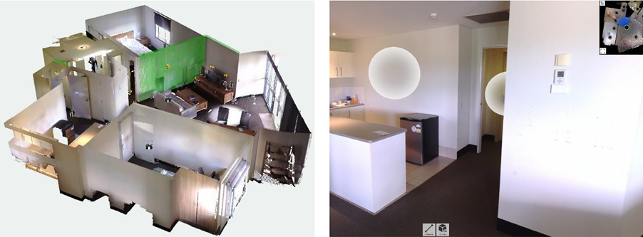
Figure 1. Example of 3D datasets provided to the OT2 team for remote analysis, 28 July 2023 (with permission from Zicheng Leon Zhu). OT, occupational therapy
Qualitative data collection method
Qualitative data were collected via informal discussion between OT1 and OT2 team members, following Swain and King (2022), for establishing the breadth and depth of collected information, which were then typed into field notes using Microsoft Word. Discussion centred on the research aims of exploring the feasibility and reliability of using LiDAR for a home risk assessment and to determine if it is superior or equal to an in-person home assessment. This included consideration of the strengths and limitations of each team and their respective method of assessment.
The qualitative data were analysed using a thematic framework, which included steps of familiarisation, generation of codes, grouping codes together into a theme, and finally reviewing and refining the themes (Ahmed et al., 2025). Due to a low sample size (n = 2), the analysis was manually conducted, as opposed to using software such as NVivo. The grouping of codes resulted in five main themes: efficiency, time, accessibility, technical challenges, and cost considerations.
Quantitative data collection method
Data were collected from 10 houses (n = 10) and then analysed using the Wilcoxon signed-rank test (Cuzick, 1985). This analysis was used due to the small size of the study and its ability to provide statistical significance in the absence of the assumption of normality (Bridge & Sawilowsky, 1999). Applying the methodology of Landis and Koch (1977), 0.81–1.00 corresponds to almost perfect agreement, 0.61–0.80 is substantial, 0.41–0.60 is moderate, 0.21–0.40 is fair, 0.00–0.20 is slight, and <0.00 is poor. Table 2 outlines the kappa values from assessing each house.
On further analysis, it was found that there was a difference between both teams that was statistically significant (p = 0.006), and the effect size was assessed as being large (d = 1.0).
Data analysis
A comparison of differences between the traditional assessment team OT1 and the digital assessment team OT2 in terms of assessment accuracy, efficiency, and participant satisfaction was undertaken. Following the assessments by the two teams, the quantitative results were compared for inter-rater reliability in (a) overall fall risk detection and (b) recommendations to reduce fall safety risks. This involved comparing how similar the two occupational therapy teams were in detecting fall risk in the community dwelling for a simulated patient using the same home safety assessment tool. For inter-rater reliability in the overall fall risk detection using the WHSAT, the results provided evidence for a fair agreement (kappa = 0.38) as shown in Table 3.
Table 3 is a summary of similarities between the two OT teams performing an in-person home safety risk assessment and a virtual LiDAR assessment. It provides the overall count for the detection of fall risks in each area of the home environment that each team assessed using the same assessment tool. The overall inter-rater reliability (κ) of 0.38, indicating a fair agreement between both teams, indicates that further investigation will be required to understand the relationship between the type of home safety assessment conducted and the use of a home safety standardised assessment tool.
For recommendations to reduce fall safety risks, comparisons between the two teams resulted in a high agreement (kappa = 0.75), as shown in Table 4.
Table 4 is a summary of similarities between the recommendations provided by the two OT teams performing in-person home safety assessments and virtual LiDAR assessments for preventative measures against fall risks in the home environments assessed. The overall inter-rater reliability (κ) was 0.75. The resultant high agreement between the two teams provides evidence that it is feasible to use LiDAR as an alternative method to conduct a home safety assessment.
Subsequently, qualitative results were reported to provide more nuanced perspectives from both occupational therapy teams and the LiDAR team regarding the strengths and weaknesses that they had encountered while undertaking their respective tasks.
Discussion and conclusion
Summary of key findings
Preliminary findings were generally positive regarding the feasibility of using LiDAR technology for home safety assessment. The high inter-rater reliability in recommendations (κ = 0.75) provides evidence for the feasibility of using LiDAR as an alternative method for home safety assessments.
Although the OT1 in-person team expressed a stronger ability to establish rapport with the client and to gain an understanding of the client’s home environment during the debrief discussions, the opportunity to review and measure visual data was valuable for those instances when manual measurement and/or specific details were inadvertently missed during the in-person visit, saving time, reducing inconvenience for the client, and avoiding the expense of a follow-up visit. The OT2 team expressed insight into the client’s lifestyle through a shorter process that could be undertaken anywhere with access to a computer and software.
There was high agreement on recommendations regarding time efficiency, as a wider range of data could be captured in a much shorter time. Moreover, the data could be stored and forwarded or further processed as required. One important aspect of time efficiency is that rapid assessment and resultant implementation of physical home modifications mean that access to independent living tailored to individual needs after a life-changing health event shortens hospital stays, mitigates the problem of allied health staff shortages, and provides more certainty for construction professionals specialising in the sector. The findings of this research demonstrate that harnessing LiDAR technology has the potential to support initiatives for ageing in place that will accelerate the process for personalised, comfortable in-home care, while enhancing the aged care and disability housing sector and its stakeholders.
Notwithstanding these key positive learnings, the teams concluded that further research was needed to address the lack of an appropriate protocol for collaboration between AECO and allied health industry professionals. For the LiDAR research team, unfamiliarity with occupational therapy assessment requirements and resultant misunderstanding of the brief led to inadequate scanning to determine issues such as ramp gradients, heights of toilet pans or other furniture items, and the lack of detail of surface textures, all of which could be significant as trip or slip hazards.
Barriers to inter-disciplinary workflow
Problem 1: Inadequate lines of communication leading to inadequate data collection
Although the WHSAT was discussed a priori, and a list of simulated injuries was provided, it was difficult for the LiDAR technician to understand the deliverables for the scan in terms of what features were critical to capture for an injury and/or home environment. The in-person visit was guided by OT1, and observation points related to clients’ lifestyle outside the nominated fall areas were noted incidentally, although these were not required to be scanned, leading to incidental information that was not available to the remote assessor OT2.
Occupational therapy foci are different from those of construction. Occupational therapists focus on the function of an individual within the home, whereas the construction focus is on design and structure. Although several different housing types were initially selected, with some highset Queenslanders in the mix, the external access was initially disregarded, and a common level base was assumed. This was partly due to the initial brief that only specified rooms were to be scanned. There was an assumption by the therapists that scanning the whole house would take too long and would not reflect what was being assessed for the simulated study. However, the outcome was that incidental observations by the OT1 team and the resultant information were not available to the OT2 team. Moreover, critical factors such as external stairs, alternative access points off steep driveways, pathways, gates, and other access and egress obstructions were not captured in the scan. Consequently, a detailed protocol is needed to mitigate issues encountered with reflective surfaces, missing point cloud data, and general misunderstandings about what is important to occupational therapists for a specific client disability condition. In one instance, miscommunication resulted in the LiDAR technician not shadowing the occupational therapist as required. Hence, the data captured were considered invalid, and the assessment needed to be redone. Subsequently, one house was scanned in its entirety (a) to demonstrate that it takes very little more time than only scanning three rooms and (b) to enable the OT2 team to gain a more nuanced understanding of the clients’ lifestyle and environment.
Problem 2: Lack of training
When scanning is completed, the data need to be processed or registered; individual scans need to be aligned and fit together. This registration process is similar to putting together a digital 3D puzzle, overlapping scan data and joining together the scan points. Once the scans are all registered, the combined deviations between the registered scans are totalled to provide an overall accuracy on which a model is based.
Technical limitations mainly related to the challenges for occupational therapists of working with these large datasets. One aspect that took unnecessary time for the OT2 team was unfamiliarity with the software and virtual measurement tools. It would have been more expeditious for the LiDAR technician to insert the measurements into the model before data delivery, leaving the therapist free to concentrate on assessment and recommendations.
LiDAR enables virtual reality walk-throughs for end-users so they can see their project in real life. This means that changes can be made before a project starts, or adjustments can be made mid-stream if design flaws are identified prior to being built.
This research has demonstrated a need for more in-depth digital technology training for health professionals to properly brief an experienced scanning technician who will handle the equipment and data processing and provide the required deliverables. Similarly, it would be advantageous for scanning technicians to have additional training in this specialist area for effective data capture. Moreover, if necessary, assessments can be reviewed while the LiDAR technician is on site, and any missing data can be identified before the technician’s return to the office. Since revisiting a site for in-person assessments is more expensive and resource-intensive than a single visit, this research shows that LiDAR has potential for saving both time and money.
Problem 3: Data sharing and single point of truth
Working collaboratively with large datasets often presents difficulties. A key issue for this research was the time taken both for occupational therapists to access data and for the LiDAR technician to facilitate such access. With no Common Data Environment (CDE) available for the research, the LiDAR technician spent considerable time, in person, assisting OT2 to download and interrogate the model. Data then had to be uploaded to the Health Sciences and Medicine research repository, to which the LiDAR technician did not have access. Within the AECO industry, in a digitally compliant project, a CDE environment would be essential, and appropriate induction would need to be provided for all stakeholders.
Essential for the delivery of digital information in the AECO industry, a CDE is simply a collaborative, controlled, and secure environment through which all stakeholders on a project can share the most up-to-date information within a centralised repository. It is an effective and efficient best practice framework for data centralisation (a single source of information) and project management, enhancing collaboration between project members. Within a CDE, an audit trail of information development and exchange is captured, coordinated, and reused across disciplines and teams, thereby reducing rework and avoiding duplication.
Summary observation
This research has demonstrated that LiDAR is a feasible auxiliary tool for improving the effectiveness and efficiency of home assessments to support independence and ageing in place. Cross-disciplinary collaboration between AECO and allied health professionals, particularly when applying BIM within the context, has potential for future expansion to additional virtual assessment procedures, leading to a deeper understanding of the community’s choices for the design of their homes and what is important to them.
Many of the problems encountered would be ameliorated by teams that are more experienced. This was a pilot study; however, future technology training and familiarity could be improved through specialised, targeted education.
Current practice in health sciences shows increased workloads for occupational therapists when performing home assessments (Brandis et al., 2023). There is limited access to rural and remote areas and limited resources such as time, travel, and effort, which lead to increased time in the hospital and a consequent shortage of available hospital resources.
The optimisation of telehealth in recent years has shown that alternative forms of home assessments are possible. The promising results of this research indicate that LiDAR has the potential for accessible remote data analysis, which is timely and cost-effective. Moreover, the technology is rapidly advancing with an emphasis on ease of use and productivity. From a practical use perspective, for example, GeoSLAM technology, developed by the CSIRO, enables autonomous, mobile “go anywhere” spatial data capture, including indoor spaces. Its software takes real-time data from lightweight LiDAR scanners that are designed for intuitive use to be deployed by anyone, without the need for specialist training. The 3D mobile mapping tools make the process faster, more reliable, and straightforward than those available for this research and show promise for future research.
Future research: collaboration for transformation
Using LiDAR in this context can make a substantial contribution to the field of occupational therapy, not only for home assessment but also for home modification, which, for construction, may be of more practical significance.
Future research aims to develop a protocol for LiDAR technicians to follow to ensure that images capture information relevant to the occupational therapy clinical decision-making process. In addition, it is evident that home risk assessment tools that are suitable for a telehealth digital environment are warranted, as current assessment tools are based on an in-person assessment. In an environment of rapid reform within aged care, disability, and telehealth, alongside advances in construction technology such as LiDAR, cross-disciplinary projects such as this fuel innovation.
“The hope is that as LiDAR use becomes normalised in the field of medicine and beyond, proper safety measures and data interpretation pipelines can be instituted to address these shortcomings and magnify LiDAR’s benefits” (Brandis et al., 2023).
Digital technology that enables accurate spatial mapping can further facilitate home assessment planning in context through the creation of an e-catalogue of commonly used assistive devices such as wheelchairs, grab rails, and walking frames for client visualisation prior to project implementation and for construction model validation. Further collaborative research on the development of an e-catalogue that includes the required range of assistive devices would be valuable for the allied health industry.
The authors wish to acknowledge and thank those who generously volunteered their homes and time. Furthermore, the authors wish to thank Bond University Faculty of Society and Design, which supported this research through an Early Career Research Grant.
Acknowledgement
We wish to acknowledge the valuable input of our respected colleague, Dr. Lynne Armitage, who sadly passed away before this work could be published. Lynne was an inspiration and driving force who is dearly missed.
Contributors: Zicheng (Leon) Zhu, Faculty of Society and Design, Bond University and Marco Leung
References
Abshire, J. (2010, 24–28 October). NASA’s space lidar measurements of Earth and planetary surfaces. Frontiers in Optics 2010: Laser Science XXVI, Rochester, New York, USA. https://doi.org/10.1364/FIO.2010.SMB1
Abshire, J. (2011, 5 April). NASA’s space lidar measurements of Earth and planets: A brief overview [PowerPoint slides]. IEEE Photonics Society Meeting, University of Maryland, USA. https://ewh.ieee.org/r2/wash_nova/photonics/archive/IeeeSpaceLidAbshireFinal4-5-11.pdf
Ahmed, S. K., Mohammed, R. A., Nashwan, A. J., Ibrahim, R. H., Abdalla, A. Q., M. Ameen, B. M., & Khdhir, R. M. (2025). Using thematic analysis in qualitative research. Journal of Medicine, Surgery, and Public Health, 6, 100198. https://doi.org/10.1016/j.glmedi.2025.100198
Almog, T., & Gilboa, Y. (2022). Remote delivery of service: A survey of occupational therapists’ perceptions. Rehabilitation Process and Outcome, 11, 11795727221117503. https://doi.org/10.1177/11795727221117503
Almukhtar, A., Saeed, Z. O., Abanda, H., & Tah, J. H. M. (2021). Reality capture of buildings using 3D laser scanners. CivilEng, 2(1), 214–235. https://doi.org/10.3390/civileng2010012
Beex, W. (2017). Lessons from LiDAR data use in the Netherlands. Studies in Digital Heritage, 1, 661. https://doi.org/10.14434/sdh.v1i2.23270
Bhandarkar, A. R., Bhandarkar, S., Jarrah, R. M., Rosenman, D., & Bydon, M. (2021). Smartphone-based light detection and ranging for remote patient evaluation and monitoring. Cureus, 13(8), e16886. https://doi.org/10.7759/cureus.16886
Brandis, S., George, J., & Rusch, R. (2023, 12 October). Home alone: Using LiDAR technology to improve home safety in older people [PowerPoint presentation]. Bond University Research Week 2023: Transformational Research.
Bridge, P. D., & Sawilowsky, S. S. (1999). Increasing physicians’ awareness of the impact of statistics on research outcomes: Comparative power of the t-test and Wilcoxon rank-sum test in small samples. Journal of Clinical Epidemiology, 52(3), 229–235. https://doi.org/10.1016/S0895-4356(98)00168-1
Burrows, P. (2023). How lidar technology can improve property valuations. Buildings Magazine. Retrieved 20 October 2024 from https://www.buildings.com/smart-buildings/article/33017910/evaluating-lidar-and-reality-capture-technology-for-property-valuations
Carrington, M., & Shahidul Islam, M. (2023). The use of telehealth to perform occupational therapy home assessments: An integrative literature review. Occupational Therapy in Health Care, 37(4), 648–663. https://doi.org/10.1080/07380577.2022.2056779
Cha, S.-M. (2025). A systematic review of home modifications for aging in place in older adults. Healthcare (Basel), 13(7), 752. https://doi.org/10.3390/healthcare13070752
Chaudhuri, S., Thompson, H., & Demiris, G. (2014). Fall detection devices and their use with older adults: A systematic review. Journal of Geriatric Physical Therapy, 37(4), 178–196. https://doi.org/10.1519/JPT.0b013e3182abe779
Clemson, L., Donaldson, A., Hill, K., & Day, L. (2014). Implementing person-environment approaches to prevent falls: A qualitative inquiry in applying the Westmead approach to occupational therapy home visits. Australian Occupational Therapy Journal, 61(5), 325–334. https://doi.org/10.1111/1440-1630.12132
Cuzick, J. (1985). A Wilcoxon-type test for trend. Statistics in Medicine, 4(4), 543–547. https://doi.org/10.1002/sim.4780040416
Dassot, M., Constant, T., & Fournier, M. (2011). The use of terrestrial LiDAR technology in forest science: Application fields, benefits and challenges. Annals of Forest Science, 68, 959–974. https://doi.org/10.1007/s13595-011-0102-2
De Souza, D., Martinez, A., & Mônaco, D. (2015, 8–10 July). The potential use of laser scanner in urban contexts. 16th International Conference CAAD Futures 2015 Sao Paulo, Brazil. https://papers.cumincad.org/data/works/att/cf2015_124.content.pdf
Dollard, C. (2021). Lidar for housing valuations. LIDAR Magazine. Retrieved 20 October 2024 from https://lidarmag.com/2021/11/15/lidar-for-housing-valuations/
Esfahani, M. E. E., Eray, E., Chuo, S., Sharif, M. M., & Haas, C. (2019, 21–24 May). Using Scan-to-BIM techniques to find optimal modeling effort: A methodology for adaptive reuse projects. Proceedings of the 36th International Symposium on Automation and Robotics in Construction (ISARC), Banff, Canada.
FARO. (2024). Introducing FARO Sphere® XG: Your digital reality platform. FARO. Retrieved 31 August from https://www.faro.com/
Filioglou, M. (2020). Atmospheric profiling using the LiDAR technique [Master’s thesis, University of Eastern Finland, Kuopio]. Finnish Meteorological Institute Atmospheric Research Centre of Eastern Finland. http://urn.fi/URN:ISBN:978-952-336-110-2
Frøvik, N., Malekzai, B. A., & Øvsthus, K. (2021). Utilising LiDAR for fall detection. Healthcare Technology Letters, 8(1), 11–17. https://doi.org/10.1049/htl2.12001
Gerring, J. (2004). What is a case study and what is it good for? American Political Science Review, 98(2), 341–354. https://doi.org/10.1017/S0003055404001182
Ghanbari, M., Rusch, R., & Skitmore, M. (2024). BIM-based environmental assessment of residential renovation projects during the operational phase. Architectural Engineering and Design Management, 20(3), 624–635. https://doi.org/10.1080/17452007.2024.2313026
Goyer, G. G., & Watson, R. (1963). The laser and its application to meteorology. Bulletin of the American Meteorological Society, 44(9), 564–570. https://doi.org/10.1175/1520-0477-44.9.564
Harrap, R., & Lato, M. (2010). An overview of LIDAR: Collection to application. NGI Publication, 2, 1–9.
Harris, S., James, E., & Snow, P. (2008). Predischarge occupational therapy home assessment visits: Towards an evidence base. Australian Occupational Therapy Journal, 55(2), 85–95. https://doi.org/10.1111/j.1440-1630.2007.00684.x
Hughes, S., Murray, C. M., McMullen-Roach, S., & Berndt, A. (2023). A profile of practice: The occupational therapy process in community aged care in Australia. Australian Occupational Therapy Journal, 70(3), 366–379. https://doi.org/10.1111/1440-1630.12860
Hwang, N. K., & Shim, S. H. (2021). Use of virtual reality technology to support the home modification process: A scoping review. International Journal of Environmental Research and Public Health, 18(21). https://doi.org/10.3390/ijerph182111096
Jamal, K. A. A., Ee, C. S., Khiyon, N. A., & Abd Wahab, N. A. (2021). Scan-to-BIM approach towards producing quantity take-off of heritage buildings in Malaysia. Journal of Engineering Science and Technology, November 2021, 120–137. https://jestec.taylors.edu.my/Special%20Issue%20THINK%20SPACE/STAAUH%2009.pdf
Kara, A., van Oosterom, P., Çağdaş, V., Işıkdağ, Ü., & Lemmen, C. (2020). 3-dimensional data research for property valuation in the context of the LADM valuation information model. Land Use Policy, 98, 104179. https://doi.org/10.1016/j.landusepol.2019.104179
Khan, M. S., Khan, M., Bughio, M., Talpur, B. D., Kim, I. S., & Seo, J. (2022). An integrated HBIM framework for the management of heritage buildings. Buildings, 12(7), 964. https://doi.org/10.3390/buildings12070964
Landis, J. R., & Koch, G. G. (1977). An application of hierarchical kappa-type statistics in the assessment of majority agreement among multiple observers. Biometrics, 33(2), 363–374. https://doi.org/10.2307/2529786
Lannin, N. A., Clemson, L., & McCluskey, A. (2011). Survey of current pre-discharge home visiting practices of occupational therapists. Australian Occupational Therapy Journal, 58(3), 172–177. https://doi.org/10.1111/j.1440-1630.2010.00911.x
Latulippe, K., Giroux, D., Guay, M., Kairy, D., Vincent, C., Boivin, K., Morales, E., Obradovic, N., & Provencher, V. (2022). Mobile videoconferencing for occupational therapists’ assessments of patients’ home environments prior to hospital discharge: Mixed methods feasibility and comparative study. JMIR Aging, 5, e24376. https://doi.org/10.2196/24376
Lauckner, H., Paterson, M., & Krupa, T. (2012). Using constructivist case study methodology to understand community development processes: Proposed methodological questions to guide the research process. The Qualitative Report, 17(Art. 25), 1–22. http://www.nova.edu/ssss/QR/QR17/lauckner.pdf
Leung, K. H. M., & Brandis, S. (2023). The smart-home study: A feasibility study to pilot the use of smartphone technology to identify environmental falls risk factors in the home. Hong Kong Journal of Occupational Therapy, 36(1), 3–12. https://doi.org/10.1177/15691861231155994
Li, X., Liu, C., Wang, Z., Xie, X., Li, D., & Xu, L. (2021). Airborne LiDAR: State-of-the-art of system design, technology and application. Measurement Science and Technology, 32(3), 032002. https://doi.org/10.1088/1361-6501/abc867
Lockwood, K. J., Harding, K. E., Boyd, J. N., & Taylor, N. F. (2020). Home visits by occupational therapists improve adherence to recommendations: Process evaluation of a randomised controlled trial. Australian Occupational Therapy Journal, 67(4), 287–296. https://doi.org/10.1111/1440-1630.12651
Markovinović, D., Lovrenčić, D., Šamanović, S., & Cetl, V. (2022, 16–17 June). 3D laser scanning for reconstruction and renovation of buildings. International Conference on Contemporary Theory and Practice in Construction/Међународна конференција Савремена теорија и пракса у градитељству, Banja Luka, Bosnia and Herzegovina. https://doi.org/10.7251/stp2215511m
Matrixian. (2023, 6 September). The future of real estate valuation: Augmented reality and lidar technology. Matrix: Revolutionize Real Estate with Data and AI. https://matrixian.com/en/the-future-of-real-estate-valuation-augmented-reality-and-lidar-technology/
Merriam, S. B. (2009). Qualitative research: A guide to design and implementation. Jossey-Bass.
Money, A. G., Atwal, A., Young, K. L., Day, Y., Wilson, L., & Money, K. G. (2015). Using the Technology Acceptance Model to explore community dwelling older adults’ perceptions of a 3D interior design application to facilitate pre-discharge home adaptations. BMC Medical Informatics and Decision Making, 15(1), 73. https://doi.org/10.1186/s12911-015-0190-2
Moss, D. (2023). Revolutionizing real estate with LiDAR scanning for property mapping. David Moss Report. Retrieved 6 September 2024 from https://www.linkedin.com/pulse/revolutionizing-real-estate-lidar-scanning-property-mapping-moss/
Müller, M. (2024). 3D lidar: From the Apollo mission to key technology for the industry [Newsletter]. Retrieved 2 September 2024 from https://www.all-about-industries.com/lidar-technology-and-autonomous-driving-a-bc4809638d1df63070dd7fd5528305a4/
National Oceanic and Atmospheric Administration (NOAA). (2012). Lidar 101: An introduction to lidar technology, data, and applications (Coastal Remote Sensing Program). https://coast.noaa.gov/data/digitalcoast/pdf/lidar-101.pdf
NDIS. (2022). NDIS home modifications: Guidance for builders and designers (Version 2) [PDF]. NDIS. www.ndis.gov.au
Nguyen, T., Nguyen, P. T., & Do, S. (2020). Application of BIM and 3D laser scanning for quantity management in construction projects. Advances in Civil Engineering, 2020, Article 8839923, 1–10. https://doi.org/10.1155/2020/8839923
Ninnis, K., Van Den Berg, M., Lannin, N. A., George, S., & Laver, K. (2019). Information and communication technology use within occupational therapy home assessments: A scoping review. British Journal of Occupational Therapy, 82(3), 141–152. https://doi.org/10.1177/0308022618786928
Nix, J., & Comans, T. (2017). Home Quick: Occupational therapy home visits using mHealth to facilitate discharge from acute admission back to the community. International Journal of Telerehabilitation, 9(1), 47–54. https://doi.org/10.5195/ijt.2017.6218
Palmon, O., Oxman, R., Shahar, M., & Weiss, P. (2004, 20-22 September). Virtual environments as an aid to the design and evaluation of home and work settings for people with physical disabilities. 5th International Conference on Disability, Virtual Reality and Associated Technologies (ICDVRAT 2004) Oxford, UK.
Poulos, R. G., Boon, M. Y., George, A., Liu, K. P. Y., Mak, M., Maurice, C., Palesy, D., Pont, L. G., Poulos, C. J., Ramsey, S., Simpson, P., Steiner, G. Z., Villarosa, A. R., Watson, K., & Parker, D. (2021). Preparing for an aging Australia: The development of multidisciplinary core competencies for the Australian health and aged care workforce. Gerontology & Geriatrics Education, 42(3), 399–422. https://doi.org/10.1080/02701960.2020.1843454
Pramod, K., & Akshay, M. C. (2022). LIDAR technology. International Journal for Research in Applied Science and Engineering Technology, 10(V May), 2976–2982. https://doi.org/10.22214/ijraset.2022.43007
Pynoos, J., Steinman, B. A., & Nguyen, A. Q. (2010). Environmental assessment and modification as fall-prevention strategies for older adults. Clinical Geriatric Medicine, 26(4), 633–644. https://doi.org/10.1016/j.cger.2010.07.001
Read, J., Jones, N., Fegan, C., Cudd, P., Simpson, E., Mazumdar, S., & Ciravegna, F. (2020). Remote home visit: Exploring the feasibility, acceptability and potential benefits of using digital technology to undertake occupational therapy home assessments. British Journal of Occupational Therapy, 83(10), 648–658. https://doi.org/10.1177/0308022620921111
Roriz, R., Cabral, J., & Gomes, T. (2022). Automotive LiDAR technology: A survey. IEEE Transactions on Intelligent Transportation Systems, 23(7), 6282–6297. https://doi.org/10.1109/TITS.2021.3086804
Skrzypczak, I., Oleniacz, G., Leśniak, A., Zima, K., Mrówczyńska, M., & Kazak, J. K. (2022). Scan-to-BIM method in construction: Assessment of the 3D buildings model accuracy in terms of inventory measurements. Building Research & Information, 50(8), 859–880. https://doi.org/10.1080/09613218.2021.2011703
Swain, J., & King, B. (2022). Using informal conversations in qualitative research. International Journal of Qualitative Methods, 21, 16094069221085056. https://doi.org/10.1177/16094069221085056
Tanner, B., Tilse, C., & de Jonge, D. (2008). Restoring and sustaining home: The impact of home modifications on the meaning of home for older people. Journal of Housing for the Elderly, 22(3), 195–215. https://doi.org/10.1080/02763890802232048
Threapleton, K., Newberry, K., Sutton, G., Worthington, E., & Drummond, A. (2017). Virtually home: Exploring the potential of virtual reality to support patient discharge after stroke. British Journal of Occupational Therapy, 80(2), 99–107. https://doi.org/10.1177/0308022616657111
Volk, R., Stengel, J., & Schultmann, F. (2014). Building information modeling (BIM) for existing buildings: Literature review and future needs. Automation in Construction, 38, 109–127. https://doi.org/10.1016/j.autcon.2013.10.023
Wu, C., Yuan, Y., Tang, Y., & Tian, B. (2022). Application of terrestrial laser scanning (TLS) in the architecture, engineering and construction (AEC) industry. Sensors, 22(1), 265. https://doi.org/10.3390/s22010265
Yin, R. K. (2018). Case study research and applications: Design and methods (6th ed.). Sage Publications.